Tarrying in the Tarryalls
- Nov 15, 2017
- 12 min read
You can hike for hours through trees, then burst upon a private universe far above roads and cities.
These summits let you taste freedom and touch the sky. They will draw you back.
-- Gerry Roach Colorado's Lost Creek Wilderness

For years, I sped down Highway 285 on my way to some destination. Each time as I descended Kenosha Pass into the vast expanse of South Park with its green ranchlands and twisting streams the color of the sky, I failed to notice the distant forest to the east. An easy oversight, as the towering, snowcapped mountains of the Continental Divide draw the gaze westward. But somewhere between the unincorporated community of Jefferson and the bustle of Colorado Springs, situated entirely within the boundaries of Pike National Forest, lies an otherworldly land known as the Lost Creek Wilderness (LCW), a land, as one writer described, that does not give up its secrets easily.
Designated as wilderness in 1980, the LCW spans 119,790 acres and includes three small mountain ranges: the Platte River, Kenosha and Tarryall Mountains. These mountain ranges were formed by some of the same geologic processes as Pike's Peak, the monarch to the southeast. These
processes include: 1) the formation of the Pike's Peak Batholith -- a large igneous intrusion of hot magma that pushed up from the earth's core and through the earth's crust approximately 1 billion years ago; It did not surface at this time and instead slowly cooled underground to form coarse granite; 2) the uplift of the ancestral Rockies about 300 million years ago -- the granite of the batholith was pushed up during this uplift and this is when Pike's Peak first emerged. The ancestral Rockies eventually eroded and became covered by sediment, and 3) the Laramide Orogeny occurred (approximately 70 to 40 mya), causing another uplift, which resulted in the present day Rocky Mountains. Pike's Peak emerged once again and now towers over the region at 14,114 feet. 4) More recently, the freezing and thawing of the Pleistocene ice age sculpted the mountains into the knobs, domes, spheres, occasional spires, and even the rare granite arch (yes there is one -- I've seen it!) that we see today. Today, the granite continues to erode, and loose, gravel-sized rock is added to the soil. This soil type contains very little water, and as a result the area is prone to wildfires. In recent decades, several fires including the Hayman fire of 2002 near Goose Creek, and the 1996 Buffalo Creek burn to the north have ravaged the area, leaving behind acres upon acres of barren areas and an interesting lesson in ecological succession.

Several rare to uncommon plants thrive in Pike's Peak granite. On sunny, south-facing slopes, Telesonix jamesii (James' saxifrage), with its hot pink flowers and deep green leaves spills abundantly from cracks in granite faces a few weeks after the diminutive blue-purple Aquilegia saximontana (Rocky Mountain blue columbine) makes its spring debut at the bases of the same boulders. Heuchera hallii thrives in natural rock gardens on eastern slopes while the more common spotted saxifrage (Saxifraga bronchialis ssp. austromontana) with its pink-freckled petals forms a moss-like carpet on rocks on shady, north-facing aspects. During early summer, moist meadows overflow with a rainbow of wildflowers including American bistort (Bistorta bistortoides), shooting stars (Dodecatheon pulchellum), wild iris (Iris missouriensis), buttercups (Ranunculus sp.), shrubby cinquefoil, and many others.

My interest in this the Lost Creek Wilderness was piqued after reading a description of a hike in James Dziezynsky's well-known book Best Summit Hikes in Colorado: An Opinionated Guide to 50+ Ascents of Classic and Little-Known Peaks from 8,144 to 14,433 feet. There was something mysterious about this wilderness and I suspected it had the potential to capture my imagination and run away with it. I laid in bed at night, scheming about hiking in it and I even planned a backpacking trip with several friends, but our plans fell through. It would be a few years before I finally experienced the LCW.

Then one summer I made it happen. Actually, some friends and I were planning a hike to the loved-to-death Conundrum Hotsprings near Aspen, but reports of lingering snow, and potentially post-holing in said snow for hours discouraged us and I suggested we do a hike in the LCW instead. Summer appears a few weeks earlier on the south-facing slopes of this wilderness, which makes for pleasant early season hiking. Soon everyone was on board and we drove the two short hours to the trailhead, threw our packs on, and set out. The hike began moderately enough, but eventually the trail began to ascend in earnest. In fact, we climbed 3,712 feet in 5.6 miles. This elevation gain felt severe with 40+ lb. backpacks and I overheard some complaining and rumors of mutiny directed at moi: while persuading my friends to do this hike, I had downplayed the total elevation gain, rounded down the total number of miles, and chose to emphasize instead that the hike was class 1 the entire way and that the beauty on the summit was reportedly breathtaking. When we finally did reach the summit, we saw the words of a previous hiker scrawled in the summit register: "This hike isn't for candy ass bitches."
At the top of Bison Peak my hiking buddies and I quickly forgot about the woes of the journey. Massive, strangely eroded, pinkish (due to feldspar) Pike's Peak granite boulders were heaped here and there and if I let me vision blur, the shapes would melt into a dozen whimsical creatures -- mountain men with long beards, ogres, and even Little Red Riding Hood. These impressive rock formations were interrupted by the relatively flat, grass-covered tundra with its bright splashes of alpine cushion plants; stands of spruce trees were huddled in groups throughout and a lonely bristlecone pine stood to the side. In the middle of all of this, a towering granite monolith stood guard, like a sentinel. To the west, the highest peaks of the Continental Divide stretched farther than my wide-angle lens could capture. For me, this was the beginning of a life-long love affair with the Lost Creek Wilderness, and I would return every chance I could.

Fast forward several years to the summer of 2017 when I got the opportunity to backpack the 27.6-mile Lost Creek Wilderness Loop, a loop that takes one into the heart of the LCW, the Tarryall Mountains. My hiking buddy and I planned to do this hike in four days, since we wanted ample time to enjoy the scenery, and looking back, I am happy with this decision. We began our hike at the Lost Park Campground and opted for a clock-wise direction in order to save some of the most magnificent scenery such as McCurdy Park, McCurdy Mountain, and the summit of Bison Peak for the latter part of the trip.
The mid-June day was sunny and warm, an iconic Colorado day with fluffy clouds floating through cerulean blue skies. We were able to relax into the hike as the beginning of the loop meanders through meadows, crosses streams, skirts beaver ponds, and dips into the cool, moist spruce-fir forests on the north side of the Tarryalls, all without much elevation gain or loss. We savored this moderate stroll, knowing it would not last.

Being a plant nerd, I scanned the ground looking for wildflowers to photograph in addition to beautiful scenery. I took as many photos as I felt socially acceptable and tried not to cross that fine line where friends and family members start to become annoyed. I'm sure some readers can relate -- you know who you are. Thankfully my hiking buddy was distracted by her own nerdy interests. Below is a photo of old man's whiskers (Geum triflorum). It was hanging out in a moist meadow. The common name refers to the plant's seedheads, which resemble the metallic pink hair of a punk rocker more than they do old man's whiskers. The flowers, which arise from a tuft of green, feathery leaves, are described by Al Schneider as "a cross between a flower, an insect, and a science fiction character" (SWColoradoWildflowers.com). They are definitely worth a closer look.

One of the beaver ponds along the way.

That night, we camped in a shady spruce-fir forest about 7 miles into the loop. The last lady slippers (Calypso bulbosa) of the season, which had faded from pink to salmon in color, littered the forest floor not far from our site and we took care not to disturb them.
The next morning we resumed hiking. Soon, we turned south where the Wigwam Trail intersects the Goose Creek Trail and the terrain immediately became drier and warmer. A few granite spires emerged, towering above the conifers and quaking aspen. This concluded the easy part of the hike.

The trail began to descend quickly and steeply through a boulder field and into Refrigerator Gulch. My knees started to wobble and I was thankful for my trekking poles, which helped me navigate the rocky path.

Along this section, the central Colorado endemic Hall's alumroot (Heuchera hallii), with its cream-colored, bell-shaped flowers, was growing abundantly in natural crevice gardens. H. hallii is similar to the Southern Rockies endemic H. bracteata. The distinguishing feature is that H. hallii has included stamens and styles whereas H. bracteata has exerted stamens and styles (FNA).

I was delighted when I saw the magenta flowers of one very early James Telesonix, which was growing on the side of a cliff. I wanted to take a photo, but I didn't deem it safe, so here's a photo from another trip. Taken on August 20th, 2016, this photo is of one of the last Telesonix to bloom that year. 2018's goal is to be up here during peak Telesonix bloom, which I've been told is early to mid July. James saxifrage is endemic to Colorado and rare, although in the South Platte River drainage it seems locally abundant. Interestingly, this species is one of two total species of the genus Telesonix in the world: the close relative, Telesonix heucheriformis, has slightly more diminutive flowers that are more purple than magenta and it is found in the Middle and Northern Rockies. As far as we know, the ranges of these two taxa do not overlap.

For awhile, the new palate of wildflowers distracted me from the unending descent. Eventually, nothing distracted me. Here is another photo of Refrigerator Gulch. I'm not sure how it got its name, but perhaps it is because the bottom of the gulch is a few degrees cooler than the higher surrounding areas...

The heart of the gulch was so tucked into the remote wilderness that I felt very far removed from civilization. The scenery is most unusual down there and the gulch seemed wild and unexplored, both fascinating and a little foreboding. This is also where the Lost Creek disappears into a cave for awhile and why the wilderness is called the Lost Creek Wilderness. My hiking buddy convinced me to walk into this cave with her. The ceilings were probably over 20 feet high in places and there was a shaft, through which light penetrated. We continued to trudge through the ice-cold waters and it got very dark and we hadn't brought our headlamps. I was too far outside of my comfort zone, so I turned around, but my hiking buddy persisted until her feet became too numb to continue.

Somewhere in this canyon, underneath a massive outcrop of rocks, is where the Lost Creek reemerges. We estimated the creek was underneath the rocks for at least 100 feet.

After appreciating the beauty for a few more moments, we threw our heavy backpacks on and followed the trail through the gulch for several miles before beginning the long, arduous climb up the east side of McCurdy Mountain. The grade was so steep in places: I felt if I leaned back I might somersault down the mountain to the bottom of the gulch. We spiraled up the mountain through canyons, traversed dense coniferous forests, and walked through aspen stands for what seemed like hours; I couldn't believe we hadn't reached some kind of a summit and it was getting late. Maybe we should have done this loop counterclockwise, I mused to my hiking buddy. Eventually, I uttered some expletives, gave up, and laid down in the middle of the trail. The Lost Creek Wilderness certainly does not give up its secrets easily... Here's a photo taken from the ground looking up at the aspens, which, at the time, appeared to be mocking me.

At long last, a good sign: An upper montane meadow, which was the first place where the ground was relative flat. For hours, we had seen no place to pitch a tent.

Soon after, we arrived at an established camping spot complete with views of rock formations and a fast-moving stream for pumping water, which was lined with marsh marigolds and a cute species of violet. I was almost too exhausted to eat, but the whiskey given to us by friendly backpackers we met at the parking lot sure hit the spot.
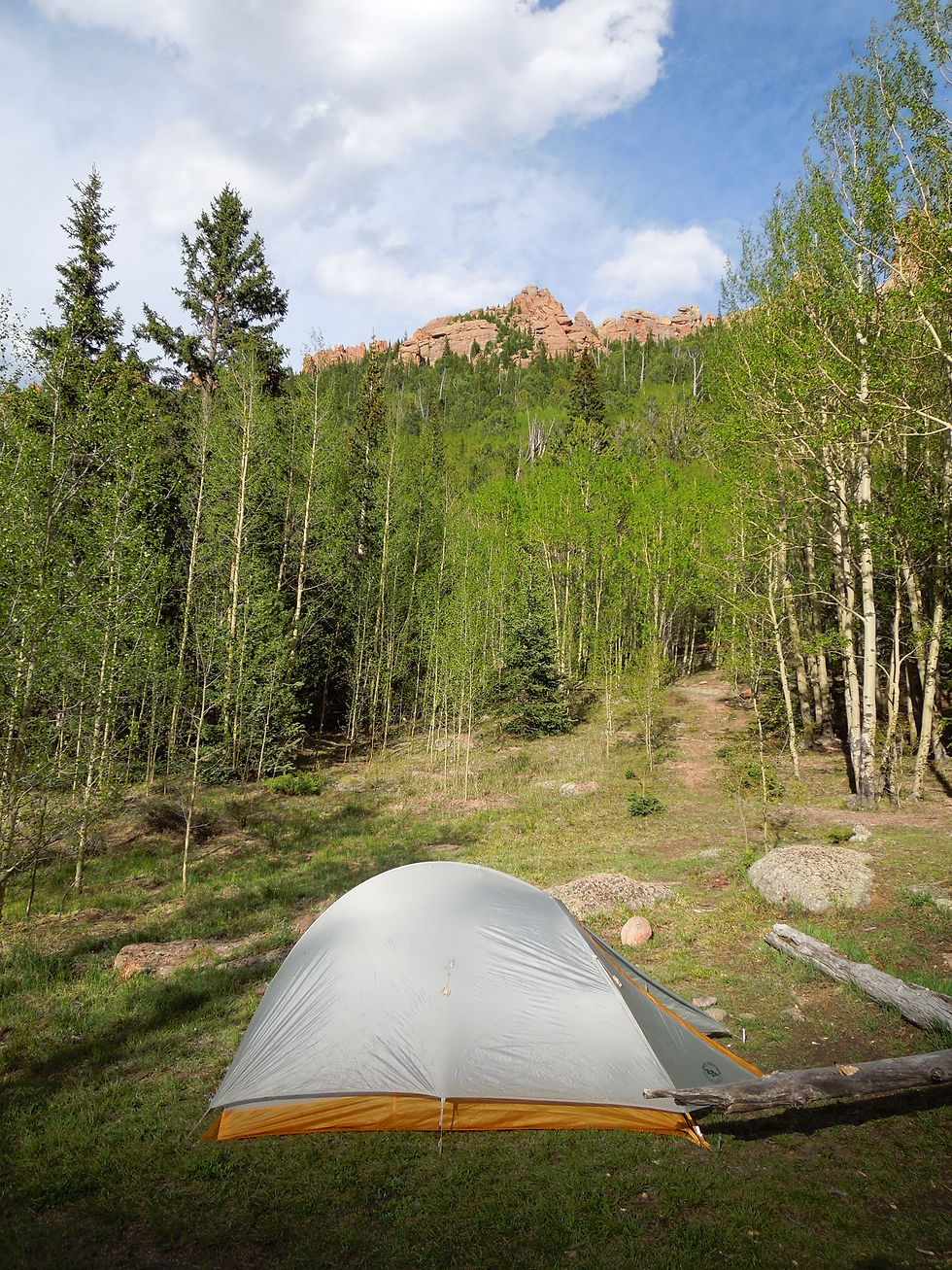
Great views from the campsite.

Day 3: Having climbed Bison Peak many times, I had ideas of what the scenery on this section might look like. I certainly expected to be wowed, but the natural beauty was even more incredible than I had imagined. Sadly, I had left my Canon SLR camera at home due to its weight, so the photos from my Nikon point and shoot will have to do, although they fall short in capturing the beauty.
Hiking on the side of McCurdy Mountain. Alpine avens (Geum rossii) in the foreground.

Looking the other direction, the views were also pretty decent.

It was in this area that I spotted a lovely cream-colored Brandegee's Jacob's ladder (Polemonium brandeegii), which was photogenically nestled in krummholz.

Lloydia serotina (common alplily) happily grows by the thousands on McCurdy Mountain. This is a dainty plant with white, greenish, or purplish-tinged star-like flowers arising from a small clump of allium-like leaves. It is circumboreal (occurs primarily in the northern part of the Northern Hemisphere) in its distribution.

The scenery became more and more dramatic and the oohing and ahhing of me and my hiking buddy increased proportionately. Here are the skeletons of conifers in front of the increasingly present Pike's Peak granite formations.

A natural granite wall creates a topographical division on McCurdy Mountain.

This colorful array of lichens could have inspired a Jackson Pollock painting.

I can no longer say I've never seen Aquilegia saximontana (Rocky Mountain blue columbine) growing in the wild!! This narrow endemic is found on cliffs and rocky slopes in the alpine and subalpine life zones in a few counties in Colorado. As depicted in the photo below, this species is much smaller than our state flower Aquilegia coerulea; the darker blue-purple flowers are nodding, and the spurs are shorter and hooked.

Androsace chamaejasme (sweet-flower rock-jasmine) peaking through resin-dotted bristlecone pine needles. In this photo, the bases of the petals are yellow, but they will age to pink (Eflora BC); often one will see both yellow and pink eyes on the same plant cushion.

Oreoxis alpina (alpine parsley) with umbels of sunny-yellow flowers.

Eritrichium nanum var. elongatum (arctic alpine forget-me-not)

Primula angustifolia (alpine primrose) is a lot pinker than this photo depicts. This plant is only found in Colorado, where it is common, and the northern mountains of New Mexico, where it is less common.

Lewisia pygmaea (pygmy bitterroot or alpine lewisia): The genus is named for Meriwether Lewis and this plant was first collected for science on the Lewis and Clark expedition (USDA Forest Service).

As day 3 drew to an end, we sat around a campfire with our freeze dried backpacker meals and contemplated the beauty in which we were immersed. It is easily understandable why Edwin James, on an 1820 expedition, referred to the Pike's Peak area as "a region of astonishing beauty."
The next morning brought a dense fog, and we hiked through misty meadows and forests en route to the summit of Bison Peak. I was excited to see the effect fog would produce on the rock formations.

We arrived at the summit (12,431 feet) just in time to see the granite monolith of Bison Peak disappear in a cloak of fog and reemerge moments later. I'm pictured to show just how massive this rock is.

The fog was dense and disorienting and the temperature seemed especially cold due to the humidity and wind, which whipped across the tundra, causing us to shiver.

The mist was creating a mysterious effect on the landscape, so we found a 20 foot tall granite boulder where we could sit and take it all in. The morning sun cast long shadows from the rock formations across the tundra. I saw my own shadow and was shocked to see a halo of rainbow-colored concentric circles surrounding it. For several moments, I observed an optical phenomenon known as a "glory" appear and disappear with the tides of the mist. (Cut and paste link for an explanation of this phenomenon: https://www.weatheronline.co.uk/reports/wxfacts/Glory.htm)

I felt as if the Lost Creek Wilderness had given up one of its secrets.

The "Glory" was ephemeral and moments later the fog burned off, exposing the bizarre rock formations once again.

As we hiked out that day, my heart was overflowing with gratitude for the remaining wilderness areas, the time I somehow find to explore them, and the people who are willing to go on these adventures with me.
The Lost Creek Wilderness is, without a doubt, one of Colorado's greatest natural treasures. Friends of Mount Evans and Lost Creek Wilderness offers opportunities for involvement in the preservation of two wilderness areas close to home:
with http://www.fomelc.org
References:
Chronic, Halka. (1980). Roadside Geology of Colorado. Mountain Press Publishing Company: Missoula, MT.
Denver, CO: The Lost Creek Wilderness Loop. (2013). Backpacker. Retrieved from: https://www.backpacker.com/trips/denver-co-lost-creek-wilderness-loop
Dziezynski, James. (2012). Best Summit Hikes in Colorado: An Opinionated Guide to 50+ Ascents of Classic and Little-Known Peaks from 8,144 to 14,433 feet. 2nd ed. Wilderness Press: Birmingham, AL.
E-Flora BC: Electric Atlas of the Flora of British Columbia. (n.d.). Retrieved from: http://ibis.geog.ubc.ca/biodiversity/eflora/vasculars.html
Flora of North America. Retrieved from: http://www.efloras.org/
Lost Creek Wilderness. (n.d.). USDA Forest Service. Retrieved from: https://www.fs.usda.gov/recarea/psicc/recarea/?recid=37208
Plant of the Week: Lewisia pygmaea. USDA Forest Service. Retrieved from: https://www.fs.fed.us/wildflowers/plant-of-the-week/lewisia_pygmaea.shtml
Roach, Gerry and Jennifer. (2001). Colorado's Lost Creek Wilderness. Fulcrum Publishing. Golden, CO.
Schneider, Al. (n.d.). Southwest Colorado Wildflowers. Retrieved from: https://www.swcoloradowildflowers.com/index.htm
The Geology of Pike's Peak. (2017). Pike's Peak America's Mountain. Retrieved from: http://www.pikespeak.us.com/Learn/geology.html
Weather Online. UK. Retrieved from: https://www.weatheronline.co.uk/reports/wxfacts/Glory.htm
Comments